
The news that Arosa and Lenzerheide, close neighbours in the Grisons canton of south east Switzerland, are to reach out across the summits and link their ski areas came as a surprise. What took them so long?
The key link is an almost flat cable-car between Arosa’s Hornli (2494m) and the Urdenfurggli ridge (2562m) above Lenzerheide. According to the very informative if somewhat schmaltzy website devoted to the SF50m project, the dream couple (‘Gigi and Heidi’) are going to tie the knot in late January. The only lift pass on sale this winter covers both resorts, which is bad luck for skiers who arrive for Christmas or New Year hoping to explore the new domain.
Why spend all that money on a cable-car when a couple of small chair or drag lifts would do the job better, from a skiing point of view, at a fraction of the cost? The cable-car will presumably be more vulnerable to closure in high wind, and there is a missed opportunity to make it a ski link. As this view of the upper valley to be spanned by the new cable car shows, the terrain is ideal for skiing.
It seems that the answer lies in green objections to any disturbance to nature, in the form of pistes or lifts, in the Urden valley, which is popular for hiking and back-country ski touring. So the hugely expensive cable-car was the only solution. This may seem strange environmental logic, but we should not rush to tell the Swiss what to do with their Alps.
The new piste map shows the arrangement, with the gap between the two areas spanned by a high wire. As usual with these schematic maps, however, there are plenty of distortions and omissions. Notably, in this case, the small village of Tschiertschen, which makes an understated appearance in the bottom centre of the plan.
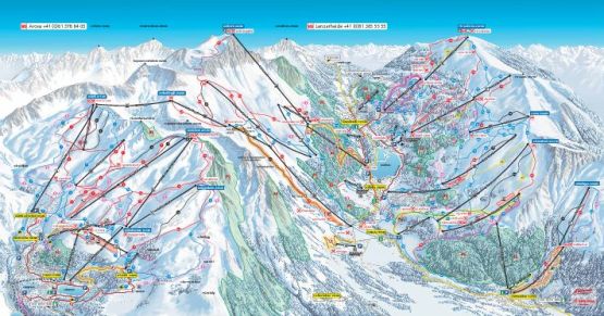
You would not guess it from the piste map, but Tschiertschen is separated from the Lenzerheide-Valbella ski area by a mountain wall and has lifts serving more than 1000 vertical metres of skiing which could have been incorporated in the new development, but have not been. As it is, they are a link in an off-piste safari for which the website mentions an expensive day ticket (SF75) for Gigi, Heidi and Tschiertschen’s ménage a trois. For those of us on holiday in Gigi-Heidiland, a better alternative would be to pay a 24 franc supplement for a ride up the mountain at Tschiertschen or 39 francs for a half day pass there if we want to do more skiing than simply pass through.
“There is no question of the Tschiertschen being opened up,” says the website, so the question has obviously come up. “It will stay as it is.” The villagers’ decision, if it was theirs, to poop the party may have something to do with not wanting to become a car park for Sunday skiers from Chur.
Heidi’s happy news prompted me to shake the dust off an early edition of The Good Skiing Guide and remind myself of its research effort. I stayed in Arosa and I have a feeling the hotelier was a mountain guide, and there may have been a detailed OS-type map of the area on the wall. Either that, or I went out and bought one, for our mapping team to use later.
These Swiss army maps show the exact location of lifts and mark the main ski runs, off-piste itineraries and terrain features well enough, in the view of a guide friend of mine, for safe off-piste skiing in an unknown place in a white-out … if you have a compass and are good enough at map-reading.
The map will have marked the run from Hornli to Tschiertschen; lifts from there to a place from which it would be possible to ski down to Lenzerheide-Valbella’s lifts, and an off-piste route from Lenzerheide’s top station, the Rothorn, back to Arosa.
The hotelier will have been consulted on the feasibility of this circuit, and he will have advised me that it presents no insuperable skiing or navigational challenge, weather and snow permitting.
After devoting the morning to a tour of the pistes at Arosa, I set off from Hornli at lunchtime. It might have been more prudent to do the safari in the morning and the piste skiing in the afternoon, but I didn’t think of that. The book describes the run, which I can’t honestly say I remember, as a ‘marked but not groomed …. no great difficulty’.
At that time Tschiertschen’s uplift went no further than a shoulder at 2040m, and from there I do vividly remember a long and exhausting cross-country push across the mountainside to reach Parpan just in time to connect with the Rothorn cable car.
Tschiertschen has since added a higher lift to 2420m, and this must make the link much more enjoyable, in good conditions. The piste map now describes my route, accurately, as a ‘fussweg’.

Rothorn to Arosa via Alplisee is a more serious adventure. I remember stopping half way down and trying to decide if I was more excited at being out in the wilds on my own at this late stage of the day, than worried about the possible consequences of a fall. Off-piste skiing alone is an interesting experience too often dismissed as foolhardy. There is risk, but risk is there to be calculated and on occasion confronted. My dedication to the research task does now strike me as rather impressive.